An overnight trip up the Clackamas River
Often, my head decides that something must be done before it allows me any processing time for other tasks. You know, the sort of thing you hit command-option-escape or control-alt-delete for when it happens to your computer. Most of these things sound pretty ridiculous if I say them out loud (or, so Rachel tells me). Usually it's something fairly mundane, like, "I have to clean out that fridge today!" Have to or what? The fridge will explode from a build-up of sulfurous gases? Fortunately, it's never gotten that bad.
So, I was a little surprised when I blurted out something like "I have to ride up the Oak Grove Fork above Lake Harriet and tramp around the woods with my fishing rod" and Rachel's response was "How can I help you get ready?" I guess I was expecting more of a talk down from the bridge sort of response, but that's not giving Rachel enough credit. She realizes better than I do that a lack of time outdoors doesn't do much for my general mood. And, as that chart-filled last post reflected, the drought has been fierce lately.
On Friday afternoon I load my gear and take a shakedown ride with Rachel out to Sportsman's Warehouse to get a fishing license. On the short climb back into the neighborhood, I start having misgivings about striking off with that load 50 miles into the woods. We stop at the bakery where she works, and after cooling off a few minutes I'd mostly forgotten my worries. Then I get home and summon Google Maps to plan out my water stops. That's when I learn it's more like 65 miles from where I sit to the little area I'd circled to look for a camping spot.
In a rare moment of sense, I say, "I can't do it. Sixty-five miles is too much right now. I'm just not up for it." Rare because I usually have thoughts like these after I'm halfway into some hare-brained mission, when turning around is harder than stumbling ahead. Taking great pride as I do in consistency, especially with regards to foolishness, I change my mind the next morning, repack to lighten the load on my Romulus, and decide to take off early Sunday morning. If nothing else, I would find out just what a 5-mile commute can prepare a cycler for, since I've done precious little else for about a year.
Sunday morning, I have a fruit smoothie and eat some leftover fried chicken, fill up two water bottles, and roll out the door a touch past 6 AM. I add no noise to the quiet Sunday morning as I pedal south down Milwaukie Ave, then 17th, and then connect with the Springwater Corridor Trail about a mile from home. The trail will take me the remaining 17 miles out to Boring, past the urban growth boundary and into farmland. In between adjusting to the loaded bike's handling and dodging rabbits, I mull over a game plan for the ride.
 Unpaved section of the Springwater Trail near Boring
I decide I'd like to maximize the odds of not blowing up on one of the climbs to come, collapsing, and falling into some river canyon. Okay, that seems reasonable. So, sticking to the plan, I soft pedal my way out of town. I enjoy the smell of the dry brush as the sun first hits it. I stop to use the restroom at Gresham city park and stop again at the Shell station in Boring for a Kit Kat and map check.
The roads are new territory from Boring to Estacada. I take Richey Rd. and then Amisigger past a golf course and berry farms. Amisigger eventually turns into a wooded country lane and tips down for a surprisingly long descent, shedding most of the 500 feet or so I've gained in about a mile. Then it's onto the wide shoulder of Highway 224, where I'll slowly gain the elevation back over the next 8 miles to Estacada. I don't realize this, though, and I mistake the false flat for a lack of energy. I start worrying about the second half of the trip beyond Estacada.
I check my watch, which isn't there, and stare at my wrist for a few long, early morning seconds. Some time later, I lean my bike against a wall, thread a thin cable lock through the rear wheel for token security, and stroll into the Estacada Thriftway with a short mental shopping list: doughnut, apple juice, Fritos, wristwatch. I've found diluted apple juice and a handful of Fritos helps ward off the heat headaches I'm prone to. I ask the check out clerk if she happens to have any cheap watches. During what seems like an awkwardly long moment, I sort of half expect her to lean in close, flip open the apron, and flash the fake Rolexes.
Instead, she thinks a second and directs me to the "High School Pharmacy." My turn for the awkward silence.
"At the high school?"
"No, that's the name, 'Hi School Pharmacy'." And she points across the street.
Hi School Pharmacy was indeed the place for cheap watches in Estacada, and I walk out $3.99 poorer, but with a whole new sense of style. I suck down the doughnut, stash the other goodies, and head out of Estacada on a pleasant sugar high.
I'm on the lookout for Faraday Rd. and find it soon enough. I had learned from Michael Wolfe that Faraday was the original road, and when they built the new one straight up and over a big hill, the old river grade route was left open for cyclists and peds. My first trip up the Clackamas (I took the bus to Estacada) I took the new road, and while the view was nice, the relentless climb alongside 65 mile per hour boat trailers was not. The old road is just as Michael said it would be, easy and pleasant.
 Faraday Dam
I roll into cool forest just as the sun heats up around 10 AM. I stop to look down at Faraday Dam, which diverts half the river via pipe and canal to a pair of artificial lakes (Faraday and Estacada), which then generate power. Or, at least I think I have that straight. There's a lot of misdirecting of water up here with the end goal of power generation. It's pretty amazing and maybe just a little creepy, moving entire rivers around for convenience and efficiency. The dam that Faraday replaced, Cazadero, washed out in the 1964-1965 floods. I would have had quite a view from up here. There is an impressive fish pass for steelhead and salmon. The structure actually switches back 180 degrees on its way up over the dam and then meanders a couple of miles through the woods before dumping the fish out in the North Fork reservoir.
Shortly after the dam, I come upon what must have been the massive landslide that blocked Michael and friend on a past trip. The exposed soil is very alien looking, with layers that looked like spirals. Or, maybe the spirals are the result of some stabilization effort? Anyway, I liked them.
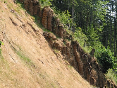 Remains of the landslide
Riding a closed road makes me realize how much mental energy I divert to listening and looking for traffic even on a mostly empty road. It really is nice, and I smell and hear more than usual as a result. The spicy damp smell of ferns, the birdsongs, the scampering chipmunks. I start thinking maybe I should get a rear view mirror and see if it has the same effect.
I come up to the imposing North Fork dam, which feels vaguely like a prison camp with all the spotlights, watchtowers, and security fence. It's also kind of beautiful in a way I can't really explain to myself. Around a bend I pass the first folks hiking up the road with fishing gear and soon I'm to the end of Faraday and back onto the highway shoulder.
At about mile 40, I stop at Lazy Bend campground to fill my water bottles. I also swap my wool jersey for a light cotton dress shirt for the hot climbing ahead. As I stow the jersey and shift food around, a fellow comes over and starts chatting. Now, let's just say this guy doesn't look like a bicycle advocate, nor does it look like he's ridden a bike any distance for a good number of years.
"Looks like ya got that bike loaded down. Where ya headin?"
"Just a little past Ripplebrook. I'll fish and camp the night and ride back."
"It's a different way to get around."
"Yeah, definitely a different pace. You see things differently."
"You see things better; that's what you do. Really can see things from a bike."
And, here I'd been expecting some offhand remark about gas prices. You never can tell. He wishes me a good ride, and I pedal off. The climb is never super steep but sort of relentless, and a hot, dry wind from behind makes it hard to stay cool in the sun, even though the temperature is pretty pleasant. I push toward the 50-mile mark. This is where I usually start to wear out, and today's no different. Despite constant snacking on nuts and fruit, I start to flag and decide to take half an hour to cool off and eat lunch. I lay my foam sleeping pad against a shade tree and feast on a bacon and greens gallette, fritos, and dried fruit.
I feel refreshed as I climb the little dirt road back to the highway, ready to tackle the final, steep climb to Ripplebrook Guard Station. As the road tips up toward a 7 percent grade, I realize I'm maybe not so refreshed after all. The sun suddenly is baking me, and my energy dives. To be fair, this is about what I expected given my preparation. I'm slow on flats, slow on downhills, but I've always been a decent climber, so it feels somehow embarrassing to fiddle with my shift levers to get up a one and a half mile climb. I know there's more climbing between me and camp, though, and I resist the urge to blow myself up now. At the top, I'm soaked with sweat and beginning to see stars despite using my lowest gear. I glance back at the river canyon I'm leaving. I'm still moving, and that's something.
A couple of mercifully shaded miles find me at Ripplebrook Guard House. Some road bikers are trickling into the parking lot, apparently finishing up a day ride. The place is crowded, and I decide to drop down the quarter mile to Ripplebrook Campground to get water. Only, there is none. It always amazes me how unreliable the forest service maps are about this key bit of information. No water at Rainbow CG, either. 0 for 2 there, NFS map. I pedal back up to Ripplebrook in a foul mood, thinking I'll have to buy bottled water from the store. The ranger there kindly directs me to a hose out front, and also tells me that Lake Harriet doesn't have water either. 0 for 3 (actually, I would learn that there is water at Lake Harriet; 0 for 1 ranger, 1 for 3 map). I guzzle a pint on the spot and fill up both bottles and my 2 quart bag, figuring this should be enough to get me to camp and back the next day.
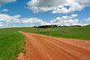
I decide to reverse my planned loop to get above Lake Harriet and take the smaller, steeper, unpaved FR-4630 up and FR-57 back down tomorrow. I'm feeling beat, and don't want to deal with the Timothy Lake traffic on FR-57. It takes me a minute to adjust to my new 4 pound, sloshing weight in the front basket, but pretty soon I'm enjoying the solitude of the shady climb up 4631/4630. The pavement ends, and I notice the dirt surface is nearly white here. When a truck passes, I get personally acquainted with this new white dust (glacial silt?). The dust is really fine, and coats all the vegetation within a couple of hundred feet of the road. Each time another vehicle passes, it's like taking a spinning class inside a vacuum cleaner for the next few minutes. Fortunately traffic is rare, and I learn it's better to just stop and wait a few minutes when someone passes.
I get occasional glimpses of the higher mountains to either side but never much of a view. It speaks to my fatigue that I don't bother taking any pictures of the entire 4630 stretch of the ride. My legs were still spinning, but I'm not sure my brain was. Traffic picks up near Lake Harriet, and I pull into the campground to confirm there's no water. I pull up to a hand pump and high comedy starring tired cycler ensues.
Well, I'll just see if it works, just hold up the bike with this hand and...Water spurts out as I move the lever through a stroke. I lose my balance a little, and the loaded bike starts heading away from my off hand. I catch it, but in doing so manage to derail the chain. Still for some reason not laying the bike down, I finagle the chain back on, getting both hands nice and greasy. The next 10 minutes are spent trying to wash my hands under a hand pump--a nearly impossible task. I can just stretch anough to have one hand under the outlet and still get leverage on the pump handle. A quart of water blasts out, and I make a little progress on the grease. Eventually I come to my senses and scrub my hands clean with dry grass, but not before what seems to have been a pretty good show for the old codger camped in the adjacent site.
 Camp
Camp
A tough graveled climb up to the junction with FR-57, and I finally relax. It feels good to have made it up here. I find a nice site on the Oak Grove Fork, set up camp, snap some photos, and head off for an evening of fishing. It's about 4 PM when I check my watch, meaning it took me about 10 hours to cover the 65 miles. Well, it beats walking! I have a nice evening on the stream, which is still too high and cold to fish worth much. I catch some small cutthroat and rainbow trout, though, which at least gets me on the board in Oregon. It's really nice to be tramping along a mountain stream again.
 Oak Grove Fork of the Clackamas River
I get back to camp a little after 8 PM, heat water for a dried soup, PBJ, and Frito dinner and then sit by the stream a while before turning in. I'm up at 6:30 AM and on the road a little after 7. I've decided to try my luck on the main stem of the Clackamas on my way back down. The descent down FR-57 is smooth and fast. I'm shivering a little, but it's a nice way to start the day. I eat a muffin and dried fruit back at Ripplebrook and before too long, I'm back near my lunch spot and the Roaring River mouth. I fish a couple of hours here and a couple more near Carter Bridge with limited success (more small rainbow). In between, I make the dangerous discovery that I can ride with my 8.5 ft flyrod fully rigged between my front basket and saddlebag, just outside my leg. the rod just flexes around corners. I'm sure to eventually break one this way, but it's great fun pedaling along in my felt-soled wading boots, ready to pounce!
Back on the road, it's a hot day in the canyon, and now the wind's in my face. I limp along, neck aching, trying to maintain some sense of decorum until I can turn off onto Faraday Rd., sit up, and weave around the empty road trying to stretch my neck and back. Something catches my eye at Faraday Dam, and I stop to look. Slowly, the dark shapes of enormous fish come into focus a hundred feet below in the river. Twenty or thirty king salmon are schooled up near the fish pass entrance, jostling for position and waiting to make their move. Occasionally, one of the brutes will leap clear of the river and come crashing down with a huge splash and crash easily audible up on the ledge above. Truly an awesome sight.
The day seems really hot as I roll into Estacada, and I'm beginning to get some leg cramps. I pull into the Thriftway looking for potassium and ice cream. I settle on an ice cream bar and pomegranate juice, which turns out to be a bad, bitter, mouth puckering combination. As I pulled into town, I'd seen the 31 bus to Portland pull in and the driver hop out for a break. There is still time to put my bike on front and avoid the hot ride back. I waver for a minute, and then point my bike back to the highway. I have to finish this ride pedaling. Where have I heard that before?
As fate would have it, I actually pass the bus again a few miles later at the Eagle Creek Rd stop, and I relish in the irony as it leaves me behind in a cloud of diesel exhaust. My back aches, my neck is killing me, and I am not much enjoying the ride on the Highway 224 shoulder. I decide to play tour rider and "power" up the hill on the other side of the Eagle Creek crossing, and that boosts my spirits a little. I imagine myself, sleeping pad rocking violently side to side, swooping out unexpectedly from a side road into the Tour De France leaders. The laugh hurts my neck but makes the pedaling feel a little lighter, and soon enough I'm turning off onto Amisigger Rd, my own little Alpe d'Huez between me and familiar roads home.
I always get butterflies when I hit an unfamiliar climb toward the end of a long ride. I gear down and spin, trying to remember things from the day before's descent. I notice how easily I can keep the heavy front end planted on the skinny fog line on this shoulderless road. It's amazing how quickly one adjusts to a loaded bike. Soon enough, I'm climbing out of the trees and the farm fields open up ahead. I come upon the bizarre sight of a blind man with guide dog, cane sweeping my edge of the road from the grassy shoulder. I'm not quite sure whether to call out or not, afraid it might startle him into the ditch. I look over my shoulder and merge into the lane, giving him a wide berth. The guide dog does his best to convey this information, but it just earns him a reprimand from his owner.
Spirits high from conquering my personal Alpe, I charge the rolling hills and soon round a corner and am greeted by Mt. Hood in the distance. It's a last reminder of how nice the mountains were before I turn left into Boring and continue toward home. The Springwater is closed unexpectedly at 182nd street, forcing me off in a part of town I don't know very well. I end up following traffic clogged Powell Blvd. as far as 92nd Ave., and the shock coming from country lanes is great. I roll in without incident, though, happy to have gone and equally happy to be home.
So, my advice to other commuters with the cyclotouriste bug? You can turn 10 commuting miles a day into a 130 mile overnighter in the mountains, but I'd suggest easing up to it. Well, unless you just have to do it next weekend.
Full photo set is here.
For the bike/gear geeks: I rode my Rivendell Romulus with Michelin Dynamic 700x32 tires. A Nitto R-15 rack and Carradice Camper saddlebag carried about 18 pounds in back. A Wald basket on the Blackburn style front rack carried another 12 pounds. Gearing was 26/36/46 in front and 13-24 in back. The setup handled well, although it took some concentration and a light grip on the bars to keep the underbuilt front rack from starting a mild speed wobble. The fishing gear adds about 8 pounds to the load.
I use a Big Agnes SL-1 Tent and a Western Mountaineering Aspen MF down bag (25 degree). I'd like to try a hammock; there are definitely more trees than nice tent sites here. Food consisted of (2) pint bags of nuts and fruit, ham & cheese croissant, bacon and greens gallette, (2) PBJ sandwiches, bag of Fritos, (2) muffins, dried lentil curry soup, apple. I had food left over.

So, I was a little surprised when I blurted out something like "I have to ride up the Oak Grove Fork above Lake Harriet and tramp around the woods with my fishing rod" and Rachel's response was "How can I help you get ready?" I guess I was expecting more of a talk down from the bridge sort of response, but that's not giving Rachel enough credit. She realizes better than I do that a lack of time outdoors doesn't do much for my general mood. And, as that chart-filled last post reflected, the drought has been fierce lately.
On Friday afternoon I load my gear and take a shakedown ride with Rachel out to Sportsman's Warehouse to get a fishing license. On the short climb back into the neighborhood, I start having misgivings about striking off with that load 50 miles into the woods. We stop at the bakery where she works, and after cooling off a few minutes I'd mostly forgotten my worries. Then I get home and summon Google Maps to plan out my water stops. That's when I learn it's more like 65 miles from where I sit to the little area I'd circled to look for a camping spot.
In a rare moment of sense, I say, "I can't do it. Sixty-five miles is too much right now. I'm just not up for it." Rare because I usually have thoughts like these after I'm halfway into some hare-brained mission, when turning around is harder than stumbling ahead. Taking great pride as I do in consistency, especially with regards to foolishness, I change my mind the next morning, repack to lighten the load on my Romulus, and decide to take off early Sunday morning. If nothing else, I would find out just what a 5-mile commute can prepare a cycler for, since I've done precious little else for about a year.
Sunday morning, I have a fruit smoothie and eat some leftover fried chicken, fill up two water bottles, and roll out the door a touch past 6 AM. I add no noise to the quiet Sunday morning as I pedal south down Milwaukie Ave, then 17th, and then connect with the Springwater Corridor Trail about a mile from home. The trail will take me the remaining 17 miles out to Boring, past the urban growth boundary and into farmland. In between adjusting to the loaded bike's handling and dodging rabbits, I mull over a game plan for the ride.
 Unpaved section of the Springwater Trail near Boring
The roads are new territory from Boring to Estacada. I take Richey Rd. and then Amisigger past a golf course and berry farms. Amisigger eventually turns into a wooded country lane and tips down for a surprisingly long descent, shedding most of the 500 feet or so I've gained in about a mile. Then it's onto the wide shoulder of Highway 224, where I'll slowly gain the elevation back over the next 8 miles to Estacada. I don't realize this, though, and I mistake the false flat for a lack of energy. I start worrying about the second half of the trip beyond Estacada.
I check my watch, which isn't there, and stare at my wrist for a few long, early morning seconds. Some time later, I lean my bike against a wall, thread a thin cable lock through the rear wheel for token security, and stroll into the Estacada Thriftway with a short mental shopping list: doughnut, apple juice, Fritos, wristwatch. I've found diluted apple juice and a handful of Fritos helps ward off the heat headaches I'm prone to. I ask the check out clerk if she happens to have any cheap watches. During what seems like an awkwardly long moment, I sort of half expect her to lean in close, flip open the apron, and flash the fake Rolexes.
Instead, she thinks a second and directs me to the "High School Pharmacy." My turn for the awkward silence.
"At the high school?"
"No, that's the name, 'Hi School Pharmacy'." And she points across the street.
Hi School Pharmacy was indeed the place for cheap watches in Estacada, and I walk out $3.99 poorer, but with a whole new sense of style. I suck down the doughnut, stash the other goodies, and head out of Estacada on a pleasant sugar high.
I'm on the lookout for Faraday Rd. and find it soon enough. I had learned from Michael Wolfe that Faraday was the original road, and when they built the new one straight up and over a big hill, the old river grade route was left open for cyclists and peds. My first trip up the Clackamas (I took the bus to Estacada) I took the new road, and while the view was nice, the relentless climb alongside 65 mile per hour boat trailers was not. The old road is just as Michael said it would be, easy and pleasant.
 Faraday Dam
I roll into cool forest just as the sun heats up around 10 AM. I stop to look down at Faraday Dam, which diverts half the river via pipe and canal to a pair of artificial lakes (Faraday and Estacada), which then generate power. Or, at least I think I have that straight. There's a lot of misdirecting of water up here with the end goal of power generation. It's pretty amazing and maybe just a little creepy, moving entire rivers around for convenience and efficiency. The dam that Faraday replaced, Cazadero, washed out in the 1964-1965 floods. I would have had quite a view from up here. There is an impressive fish pass for steelhead and salmon. The structure actually switches back 180 degrees on its way up over the dam and then meanders a couple of miles through the woods before dumping the fish out in the North Fork reservoir.
Shortly after the dam, I come upon what must have been the massive landslide that blocked Michael and friend on a past trip. The exposed soil is very alien looking, with layers that looked like spirals. Or, maybe the spirals are the result of some stabilization effort? Anyway, I liked them.
 Remains of the landslide
Riding a closed road makes me realize how much mental energy I divert to listening and looking for traffic even on a mostly empty road. It really is nice, and I smell and hear more than usual as a result. The spicy damp smell of ferns, the birdsongs, the scampering chipmunks. I start thinking maybe I should get a rear view mirror and see if it has the same effect.
I come up to the imposing North Fork dam, which feels vaguely like a prison camp with all the spotlights, watchtowers, and security fence. It's also kind of beautiful in a way I can't really explain to myself. Around a bend I pass the first folks hiking up the road with fishing gear and soon I'm to the end of Faraday and back onto the highway shoulder.
At about mile 40, I stop at Lazy Bend campground to fill my water bottles. I also swap my wool jersey for a light cotton dress shirt for the hot climbing ahead. As I stow the jersey and shift food around, a fellow comes over and starts chatting. Now, let's just say this guy doesn't look like a bicycle advocate, nor does it look like he's ridden a bike any distance for a good number of years.
"Looks like ya got that bike loaded down. Where ya headin?"
"Just a little past Ripplebrook. I'll fish and camp the night and ride back."
"It's a different way to get around."
"Yeah, definitely a different pace. You see things differently."
"You see things better; that's what you do. Really can see things from a bike."
And, here I'd been expecting some offhand remark about gas prices. You never can tell. He wishes me a good ride, and I pedal off. The climb is never super steep but sort of relentless, and a hot, dry wind from behind makes it hard to stay cool in the sun, even though the temperature is pretty pleasant. I push toward the 50-mile mark. This is where I usually start to wear out, and today's no different. Despite constant snacking on nuts and fruit, I start to flag and decide to take half an hour to cool off and eat lunch. I lay my foam sleeping pad against a shade tree and feast on a bacon and greens gallette, fritos, and dried fruit.
I feel refreshed as I climb the little dirt road back to the highway, ready to tackle the final, steep climb to Ripplebrook Guard Station. As the road tips up toward a 7 percent grade, I realize I'm maybe not so refreshed after all. The sun suddenly is baking me, and my energy dives. To be fair, this is about what I expected given my preparation. I'm slow on flats, slow on downhills, but I've always been a decent climber, so it feels somehow embarrassing to fiddle with my shift levers to get up a one and a half mile climb. I know there's more climbing between me and camp, though, and I resist the urge to blow myself up now. At the top, I'm soaked with sweat and beginning to see stars despite using my lowest gear. I glance back at the river canyon I'm leaving. I'm still moving, and that's something.
A couple of mercifully shaded miles find me at Ripplebrook Guard House. Some road bikers are trickling into the parking lot, apparently finishing up a day ride. The place is crowded, and I decide to drop down the quarter mile to Ripplebrook Campground to get water. Only, there is none. It always amazes me how unreliable the forest service maps are about this key bit of information. No water at Rainbow CG, either. 0 for 2 there, NFS map. I pedal back up to Ripplebrook in a foul mood, thinking I'll have to buy bottled water from the store. The ranger there kindly directs me to a hose out front, and also tells me that Lake Harriet doesn't have water either. 0 for 3 (actually, I would learn that there is water at Lake Harriet; 0 for 1 ranger, 1 for 3 map). I guzzle a pint on the spot and fill up both bottles and my 2 quart bag, figuring this should be enough to get me to camp and back the next day.
I decide to reverse my planned loop to get above Lake Harriet and take the smaller, steeper, unpaved FR-4630 up and FR-57 back down tomorrow. I'm feeling beat, and don't want to deal with the Timothy Lake traffic on FR-57. It takes me a minute to adjust to my new 4 pound, sloshing weight in the front basket, but pretty soon I'm enjoying the solitude of the shady climb up 4631/4630. The pavement ends, and I notice the dirt surface is nearly white here. When a truck passes, I get personally acquainted with this new white dust (glacial silt?). The dust is really fine, and coats all the vegetation within a couple of hundred feet of the road. Each time another vehicle passes, it's like taking a spinning class inside a vacuum cleaner for the next few minutes. Fortunately traffic is rare, and I learn it's better to just stop and wait a few minutes when someone passes.
I get occasional glimpses of the higher mountains to either side but never much of a view. It speaks to my fatigue that I don't bother taking any pictures of the entire 4630 stretch of the ride. My legs were still spinning, but I'm not sure my brain was. Traffic picks up near Lake Harriet, and I pull into the campground to confirm there's no water. I pull up to a hand pump and high comedy starring tired cycler ensues.
Well, I'll just see if it works, just hold up the bike with this hand and...Water spurts out as I move the lever through a stroke. I lose my balance a little, and the loaded bike starts heading away from my off hand. I catch it, but in doing so manage to derail the chain. Still for some reason not laying the bike down, I finagle the chain back on, getting both hands nice and greasy. The next 10 minutes are spent trying to wash my hands under a hand pump--a nearly impossible task. I can just stretch anough to have one hand under the outlet and still get leverage on the pump handle. A quart of water blasts out, and I make a little progress on the grease. Eventually I come to my senses and scrub my hands clean with dry grass, but not before what seems to have been a pretty good show for the old codger camped in the adjacent site.
 Camp
Camp Oak Grove Fork of the Clackamas River
I get back to camp a little after 8 PM, heat water for a dried soup, PBJ, and Frito dinner and then sit by the stream a while before turning in. I'm up at 6:30 AM and on the road a little after 7. I've decided to try my luck on the main stem of the Clackamas on my way back down. The descent down FR-57 is smooth and fast. I'm shivering a little, but it's a nice way to start the day. I eat a muffin and dried fruit back at Ripplebrook and before too long, I'm back near my lunch spot and the Roaring River mouth. I fish a couple of hours here and a couple more near Carter Bridge with limited success (more small rainbow). In between, I make the dangerous discovery that I can ride with my 8.5 ft flyrod fully rigged between my front basket and saddlebag, just outside my leg. the rod just flexes around corners. I'm sure to eventually break one this way, but it's great fun pedaling along in my felt-soled wading boots, ready to pounce!
Back on the road, it's a hot day in the canyon, and now the wind's in my face. I limp along, neck aching, trying to maintain some sense of decorum until I can turn off onto Faraday Rd., sit up, and weave around the empty road trying to stretch my neck and back. Something catches my eye at Faraday Dam, and I stop to look. Slowly, the dark shapes of enormous fish come into focus a hundred feet below in the river. Twenty or thirty king salmon are schooled up near the fish pass entrance, jostling for position and waiting to make their move. Occasionally, one of the brutes will leap clear of the river and come crashing down with a huge splash and crash easily audible up on the ledge above. Truly an awesome sight.
The day seems really hot as I roll into Estacada, and I'm beginning to get some leg cramps. I pull into the Thriftway looking for potassium and ice cream. I settle on an ice cream bar and pomegranate juice, which turns out to be a bad, bitter, mouth puckering combination. As I pulled into town, I'd seen the 31 bus to Portland pull in and the driver hop out for a break. There is still time to put my bike on front and avoid the hot ride back. I waver for a minute, and then point my bike back to the highway. I have to finish this ride pedaling. Where have I heard that before?
As fate would have it, I actually pass the bus again a few miles later at the Eagle Creek Rd stop, and I relish in the irony as it leaves me behind in a cloud of diesel exhaust. My back aches, my neck is killing me, and I am not much enjoying the ride on the Highway 224 shoulder. I decide to play tour rider and "power" up the hill on the other side of the Eagle Creek crossing, and that boosts my spirits a little. I imagine myself, sleeping pad rocking violently side to side, swooping out unexpectedly from a side road into the Tour De France leaders. The laugh hurts my neck but makes the pedaling feel a little lighter, and soon enough I'm turning off onto Amisigger Rd, my own little Alpe d'Huez between me and familiar roads home.
I always get butterflies when I hit an unfamiliar climb toward the end of a long ride. I gear down and spin, trying to remember things from the day before's descent. I notice how easily I can keep the heavy front end planted on the skinny fog line on this shoulderless road. It's amazing how quickly one adjusts to a loaded bike. Soon enough, I'm climbing out of the trees and the farm fields open up ahead. I come upon the bizarre sight of a blind man with guide dog, cane sweeping my edge of the road from the grassy shoulder. I'm not quite sure whether to call out or not, afraid it might startle him into the ditch. I look over my shoulder and merge into the lane, giving him a wide berth. The guide dog does his best to convey this information, but it just earns him a reprimand from his owner.
Spirits high from conquering my personal Alpe, I charge the rolling hills and soon round a corner and am greeted by Mt. Hood in the distance. It's a last reminder of how nice the mountains were before I turn left into Boring and continue toward home. The Springwater is closed unexpectedly at 182nd street, forcing me off in a part of town I don't know very well. I end up following traffic clogged Powell Blvd. as far as 92nd Ave., and the shock coming from country lanes is great. I roll in without incident, though, happy to have gone and equally happy to be home.
So, my advice to other commuters with the cyclotouriste bug? You can turn 10 commuting miles a day into a 130 mile overnighter in the mountains, but I'd suggest easing up to it. Well, unless you just have to do it next weekend.
Full photo set is here.
For the bike/gear geeks: I rode my Rivendell Romulus with Michelin Dynamic 700x32 tires. A Nitto R-15 rack and Carradice Camper saddlebag carried about 18 pounds in back. A Wald basket on the Blackburn style front rack carried another 12 pounds. Gearing was 26/36/46 in front and 13-24 in back. The setup handled well, although it took some concentration and a light grip on the bars to keep the underbuilt front rack from starting a mild speed wobble. The fishing gear adds about 8 pounds to the load.
I use a Big Agnes SL-1 Tent and a Western Mountaineering Aspen MF down bag (25 degree). I'd like to try a hammock; there are definitely more trees than nice tent sites here. Food consisted of (2) pint bags of nuts and fruit, ham & cheese croissant, bacon and greens gallette, (2) PBJ sandwiches, bag of Fritos, (2) muffins, dried lentil curry soup, apple. I had food left over.

Labels: bike packing, ride stories
posted by Joe at 10:37 AM
![]()

3 Comments:
Hi Joe -- Enjoyed your story. Sounds like a great ride. Sometimes paying the toll in effort makes the rewards sweeter.
See ya,
Mark
Thanks for the excellent write-up. Sounds like a very successful adventure. I also dig the bike/gear details and would love to read more about the fishing gear/story. (The fishing part of bike-fish-camp during an overnight trip is the part that still eludes me in my present location, so I especially enjoyed your description. Nice writing style, too.)
very cool story Joe. I am curios. What model bike did you use for this trip?
Post a Comment
<< Home